
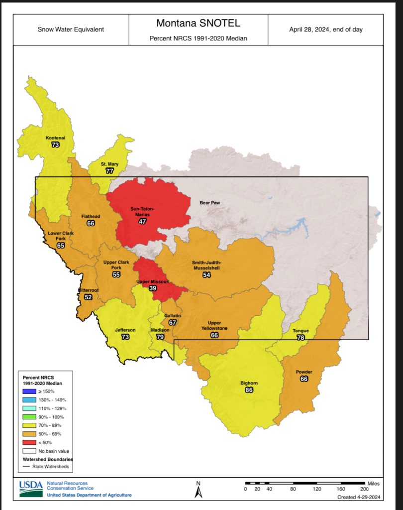
Lots of doom and gloom out there but here in the Madison Basin which includes the areas upstream of the Madison River, we are in decent shape compared to the rest of the state. West Yellowstone and YNP have received some good moisture lately. We are at 79% of normal snowpack and above that in some areas of YNP. Not such good news for Sun-Teton-Marias areas at 47%…same bleak outlook for Blackfoot, Shields and Big Hole rivers…under 60%. Upper Missouri a concern at 35%. Bighorn, however, looking good at 86% of normal moisture.
Click on the links included in this article below to see the big picture across the state courtesy DNRC. It is quite detailed and includes extensive data.
Spring moisture needed to boost river flows, report notes
- Brett French
- Apr 18, 2024
- Butte, Montana Standard.
Boaters may want to launch their river craft earlier this spring as the forecast for summer water levels appears grim.
“The outlook for spring and summer runoff is currently poor and stream flows are likely to taper off earlier than usual this summer,” according to the Department of Natural Resources and Conservation’s spring water supply report. Michael Downey, Drought Program coordinator for the agency, compiled the information.


Paddling rivers could be tougher with April to July stream flows forecast at 70% to 85% of normal, according to the Natural Resources Conservation Service April Water Supply Outlook Report.
Meanwhile, many Montana reservoirs are holding more water than normal as dam managers prepare for less runoff.
“For example, Dead Man’s Basin reservoir (near Harlowton) at the end of March was 126% of normal with 64,633 acre-feet of storage.” Last year at this time, the reservoir “held only 42,614 acre-feet, the result of three years of severe drought and high irrigation demand.”
On the western side of the state, however, “Hungry Horse, Lake Kootenai, and Flathead Lake are likely to receive below average inflows due to low snowpack.” There’s also concern that reservoirs along the Milk River in northern Montana will be lower.
Go time for rain
The amount of moisture that falls in the next eight weeks will be crucial, the report noted, as the snowpack in most of the state’s subbasins was “well below” 75% at the beginning of April.
“Depending on temperatures and accumulated precipitation, conditions have the potential to improve or degrade statewide,” the report said. “Everyone that relies upon stream flows for a water source should prepare for a challenging summer following the warm and dry winter and low snowpack.”
The setup
Last year’s weather set the stage for this spring’s uncertainty. Here are some records the report underlined.
• July through December was the warmest on record, with the average temperature 4 degrees hotter. May through September was the second warmest on record. December of 2023 was the warmest on record with the statewide average exceeding 10 degrees above normal.
• Given the mild December, it’s no wonder that Montana’s high elevation Snow Telemetry (SNOTEL) Network sites set new record lows for November and December snowpack.
• The period from June 10 to Aug. 20 was also exceptionally dry, resulting in record low stream flows and greatly diminished soil moisture in some areas. By early September, 40% of the state was in moderate to extreme drought.
• Although February 2024 finally brought above normal precipitation for all the state’s river basins, except the Tongue, the month also saw warmer than average temperatures that melted off much of the snow.
“According to the Natural Resources Conservation Service Snow Survey Program, of the 281 snow monitoring stations measured for April 1st, 46 of those are currently the second lowest or lowest on record. 111 stations are still reporting a much below average snowpack.”
Looking ahead
“Conditions this summer will hinge on both temperature and precipitation over the next three months,” the report said.
April, May and June are some of the wettest months of the year east of the Continental Divide. To the west, however, “precipitation generally tapers off as summer approaches.”
“With warmer than average temperatures forecast for the next three weeks and no clear signal for precipitation, it is possible that the lower elevation snowpack has already reached its peak for the season in most watersheds,” according to the report. “High elevation sites will likely continue to increase snowpack into mid-May.”
Particularly vulnerable going into the spring is the northern third of the state, which has weathered “multi-year precipitation deficits and a very warm winter.”
The National Oceanic and Atmospheric Administration’s seasonal drought outlook through June 30 shows much of western Montana and the northeast as regions where drought will persist, with the west also forecast to have warmer temperatures.
Only the southeast corner of the state is forecast for possible above normal precipitation.
As of April 1, the Sun-Teton-Marias river basin had the lowest snowpack at 57%, compared to the Bighorn River basin which had the highest at 95%. The lack of snow means the April to July stream flows on the Teton and Sun rivers is forecast to be near record lows.
“The Blackfoot River, Little Bighorn River, Musselshell River, Nevada Creek, Shields River, and Big Hole River near Wisdom are all forecast to have less than 60% of normal stream flows during the April-July period.